There is an age-old cartography problem: How can the surface of a sphere be most accurately reproduced on an even surface?
For centuries, mathematicians, cartographers and geographers have been looking for a solution to this problem and, in the process, have come up with a considerable number of projections and maps. Every single one of these has since been optimized for a specific purpose. Whatever your subject, topography, navigation, climate or geology, radio broadcasting coverage studies, the choice is yours when it comes to maps.
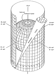
Over 400 years ago, the autodidact Gerardus Mercator from Flanders completed the very first book containing nothing but maps, the first atlas. Even today, the Mercator projection (in which the surface of the earth is projected with mathematical accuracy onto a surrounding cylinder) is still one of the most common types of map.
On this type of map the direction remains true, making it particulary practical for navigation at sea.
Exact surfaces and distances are not represented everywhere, so the straight lines come out curved.
Just as it is impossible to wrap an orange without wrinkling the paper, no map can depict our earth without some distortion.
Twenty years ago, researchers came up with a special projection for the reproduction of satellite photos, yet still there is not a map in the world to compete with a globe. The directions may be fine, but the distances and sur-faces wrong, or the contours of the northern and southern countries may look strangely bloated.
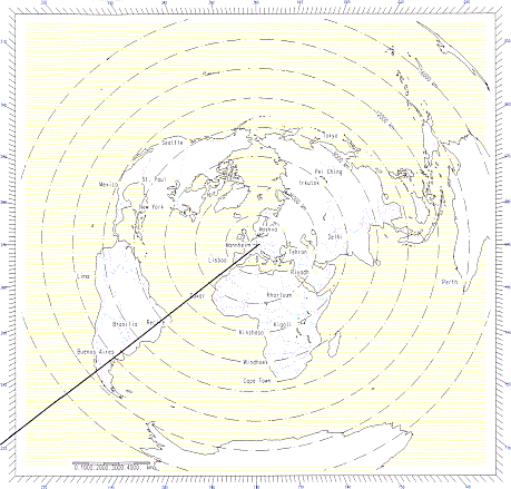
For the selection of an optimum antenna for long distant short-wave broadcasting engineers are fond of a "great circle map", as shown below. Although this map can as well not compete with a globe, directions and distances are fine, but country and continent contours may be strongly distort, if distance from center point (transmitter
location) to points of coverage (receiver locations) is very large (>10.000km).
The antipode situation explains why the equidistant reproduction on an even surface results in such strong distortions, simply because you may reach the antipode location, regardless of your azimuth of departure and that means the antipode point becomes a circle.
Assuming the contours of continents, oceans and lakes, the contours of countries and the location of cities are available as digital data, the great circle map can be reproduced using simple formulas:
Distance: D (km) = 111.198 * inv cos ((sin φ1 * sin φ2 + cos φ1 * cos φ2 * cos (λ1 - λ2))
with:
φ1 (°) = geographic latitude of transmitter location
φ2 (°) = geographic latitude of receiver location
λ1 (°) = geographic longitude of transmitter location
λ2 (°) = geographic longitude of receiver location
111.198 = 2πR/360°, whereas R = 6371,2 km
D° (°) = D (km) / 111.198 (km/°)
whereas: northern latitude and western longitude shall have positive sign
southern latitude and eastern longitude shall have negative sign
Angle of Azimuth true North - East of North (°)
transmitter towards receiver:
φT-R = inv cos (( sin φ2 - sin φ1 * cos D°) / cos φ1 * sin D° )
receiver towards transmitter:
φR-T = inv cos (( sin φ1 - sin φ2 * cos D°) / cos φ2 * sin D° )
note:
if sin ( λ1 - λ2) < 0 then φT-R = 360° - φT-R
if sin ( λ2 - λ1) < 0 then λR-T = 360° - φR-T
Example:From (49°30' N 8°43' E) Mannheim, Germany to (34°40' S 58°30' W) Buenos Aires, Argentina
D = 111.198 * inv cos ((sin 49.5 * sin (-34.67) + cos 49.5 * cos
(-34.67) * cos ( -8.72 - 58.5)) = 11'458.09 (km) Angle of Azimuth true North (°)
φT-R transmitter towards receiver, i.e. Mannheim to Buenos Aires
= inv cos (( sin (-34.67) - sin 49.5 * cos 11458.09/111.198) / cos 49.5 * sin 11458.09/111.198 ) = 231.11°
φR-T receiver towards transmitter, i.e. Buenos Aires to Mannheim:
= inv cos (( sin 49.5 - sin (-34.67) * cos 11458.09/111.198) / cos (-34.67) * sin 11458.08/111.198 ) = 37.78°
Great Circle Map centered to Mannheim, Germany (49°30' N 8°43' E)
Mannheim to Buenos Aires Distance 11'458.09 km Azimuth 231.11°